Skip to content

Subsurface

George Kourakos

  • Home
  • Curriculum vitae
  • Publications
    • Journals
    • Conferences (Oral Talks)
    • Conferences (Posters)
    • Reports
    • Theses
  • Software
    • mSim
      • Download
      • Tutorials
      • Publications
      • Links
      • Documentation
    • Modflow Utilities
    • Equal Area
    • Stream Depletion Analysis Tool
    • WTRBLN
  • Blog
    • Programming Tips
      • Compilation guides
      • IWFM
      • Git basic commands
    • Software Tips
    • Linux Tips
    • Uncategorized Posts

Software Tips

How to fix zoom issue in QGIS

Posted on October 2, 2015April 11, 2016 by Giorgos Kourakos

Recently I got this very irritating problem that some of my shapefiles where not displayed while zooming.

For my case the solution was very easy:

1) Under the Layers menu right click on the problematic shapefiles and choose properties.

2) Under the General tab click Create spatial index.

Done!
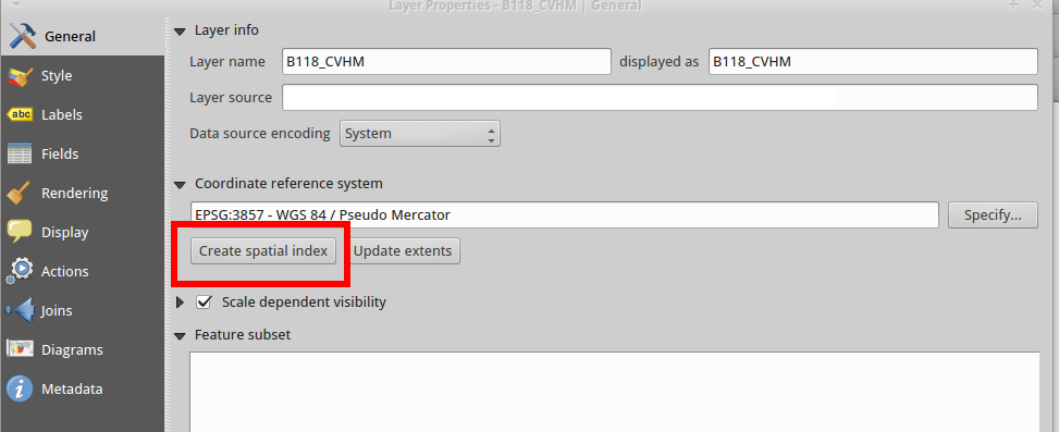
Selection_009a


Posted in Software TipsLeave a comment

Posts navigation

Newer posts →

Recent Posts

  • Read custom data in UE4
  • Subplots in Matlab
  • Reading IWFM/C2VSim Output files
  • GIS projections in Matlab and R
Proudly powered by WordPress